Blogger Mapping Options
1/17/2010 Update: Blogger's Geotagging method is still only available in draft mode after over a year. It has been broken a couple of times and there is still no Blogger supported method for geotagging posts via email.
Note: This post was originally posted on BlogsMapr (our BlurbBits Blogger playground). We wanted to test/support the new Blogger-in-Draft geotagging editor and answer some questions about why you'd want to geotagged posts (can you believe they asked?). We continue to use BlurbBits in our Sailing Blog (via standard Blogger) because it supports remote blogging, has more configurability AND you can specify a locations zoom level on a post by post basis. We have a documented migration path for when the editor becomes more mainstream (and by then we'll be sure to have a utility).
Now What?
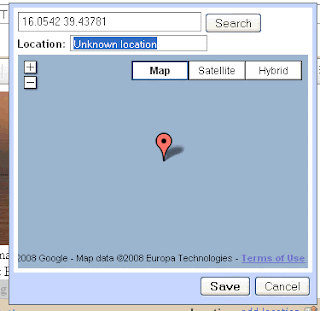
You've defined post locations via Blogger-in-Draft, our position text input (for Mail-to-blogger) or by adding stand alone BlurbBits to your posts (to add routes and photos etc).. So now what?
Well we've been GeoBlogging for 3.5 years, using Blogger to track our 5 year 30,000 mile sailing trip, so we've got some ideas and some tools. Here are some cool things you can do with BlurbBits and related utilities.
To see all of our online Sailing content including our Webpage journals and photos, Youtube videos, Blogger posts and KML GPS tracks click here. This data was entered in the BlurbsBits Mapr scratchpad which can be uploaded to the web via Google Spreadsheets.
Note: This post was originally posted on BlogsMapr (our BlurbBits Blogger playground). We wanted to test/support the new Blogger-in-Draft geotagging editor and answer some questions about why you'd want to geotagged posts (can you believe they asked?). We continue to use BlurbBits in our Sailing Blog (via standard Blogger) because it supports remote blogging, has more configurability AND you can specify a locations zoom level on a post by post basis. We have a documented migration path for when the editor becomes more mainstream (and by then we'll be sure to have a utility).
Now What?
You've defined post locations via Blogger-in-Draft, our position text input (for Mail-to-blogger) or by adding stand alone BlurbBits to your posts (to add routes and photos etc).. So now what?
Well we've been GeoBlogging for 3.5 years, using Blogger to track our 5 year 30,000 mile sailing trip, so we've got some ideas and some tools. Here are some cool things you can do with BlurbBits and related utilities.
- Blogger Popup maps and a Dynamic GeoBlog Summary map
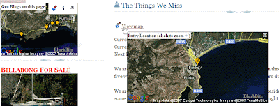
Each post with a defined location will have a popup map within your Blog. In addition, a GeoBlogs on this Page summary map is dynamically created based on the posts on each page. If posts are filtered by searching, labels or selecting an archive month or year, the map will automatically change to show only the relevant geoblog posts. It's a great way to visualize blogs locations for a year or specific area (via label).
Open our Sailing Blog (standard Blogger) or BlurbBits Playground (Blogger-in-draft) and notice the View map links. They were automatically added via our gadget.
Click on the link to display a quick Google Static Map of the location directly within Blogger (no new page to open). An additional click, in the map, will display the zoomed out view. Try selecting a Blog Archive month and watch the Geo-Blogs map change. - Navigate your blog via an interactive map

Not only do you get to see your blog locations on an interactive map, we also extract a summary of each post and the first photo for a preview. We maintain the map and open your blog pages directly in the window below (select from the list on the top right or click the [more] link in the preview). The map stays persistent allowing the user to smoothly navigate your geoblog posts.
On the Add Page Element page clickEdit Contentand adjust YOURBLOG to the correct location (ie. YOURBLOG.blogspot.com .. blogsmapr for this Blog). If you use FTP posted blogs change blogger=YOURBLOG to bloggerid=BLOGID (blogID=XXX in the post editor URL). Click here for more BlurbsViewr details and options. - Extract a map for selected Blog posts to embed or email. Maps can be customized based on the desired number of posts and/or filtered by categories/labels. Click the i Info button to select various publishing options. The BlurbBits in the sidebar were extracted from other blogs. Learn how to adjust the widget size for sidebar vs post installs.
- Create a "Where Blog map" to embed or email showing the latest geoblog location with a link to the latest post. Same as above using &mv=where and &mi=in.
- Create a GeoBlog photo album. This method extracts the first photo (so make it good) and the post location to create a photo album for the blog. Posts which are geotagged will appear with a Location map button. A short blog summary can be previewed by selecting the notes button. Add &bp=1 to the extract a map example.
Photos stored online with Picasa or Flickr can be displayed in the same album BlurbBit format, examples are scattered throughout all our blogs.
To see all of our online Sailing content including our Webpage journals and photos, Youtube videos, Blogger posts and KML GPS tracks click here. This data was entered in the BlurbsBits Mapr scratchpad which can be uploaded to the web via Google Spreadsheets.


